WorldTidesInfoCustom
jugla
On Home Assistant 2026.11 or newer? Open it in the Marketplace
- Installs
- 123 sharing analytics
- GitHub stars
- 33
- Connection
- Uses the vendor's cloud
- Upkeep
- No update in over 18 months
- Version
- V13.2.0,
- Category
- Security and safety, Cameras
- Kind
- Marketplace integration
- Needs
- Needs the Marketplace (HACS on 2026.10 and older)
- Domain
worldtidesinfocustom- Issues
- Report an issue
Independent directory, made by the developer of Vulpo. Not affiliated with Home Assistant or the Open Home Foundation.
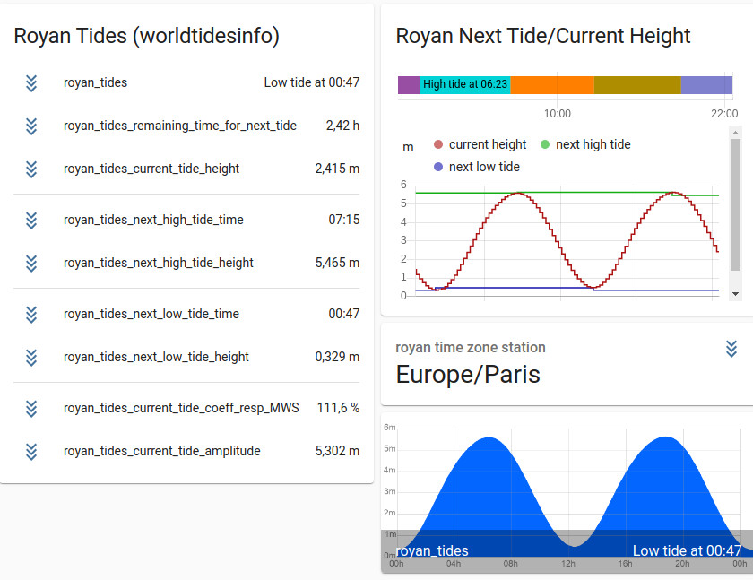
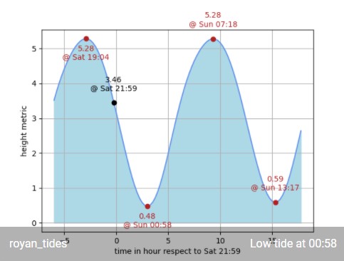
Screenshots From the README of jugla/worldtidesinfocustom.
About
WorldTidesInfoCustom is an integration that retrieves tide information for any location from the WorldTidesInfo cloud service. It adds sensors for the current tide height, a forecast height one hour ahead, the next tide, and tide tendency and amplitude. Cameras plot the tide curve against the current prediction, and tide extrema can be inserted into a calendar. The monitored location can be fixed coordinates or follow a tracker, and the reference point updates once the tracker moves beyond a set distance. Configuration covers an API key, vertical reference, prediction period in days, tidal station distance, and plot colors with an optional transparent background. It is set up in the UI and needs a WorldTidesInfo API key, which works on a credit basis.
Automatic summary of the README and code of jugla/worldtidesinfocustom. Something wrong, or are you the maintainer and want your own text here? Get in touch
Supports
Uses the vendor's cloud Needs an internet connection and an account with the vendor.
From the Marketplace Installed through the Marketplace, formerly HACS.
Provides
- Cameras
- Sensors
- Calendars
Setting it up
Install it from the Marketplace and restart Home Assistant, then add it under Settings, Devices and services.
Configure WorldTidesInfoCustom
- Type of configuration
Configure standard
- name
- api key of world tides info
- location latitude
- location longitude
Configure standard with moving sensor
- name
- api key of world tides info
- location latitude for init
- location longitude for init
- location is static or dynamic from_sensor
- source id that contains lat/long
- latitude attribute name of sensor id
- longitude attribute name of sensor id
Configure expert
- name
- api key of world tides info
- location latitude
- location longitude
- vertical reference
- tidal station distance
- tide prediction duration in day
- plot curve color in comma-separated RGB values
- plot curve background color in comma-separated RGB values
- metric HA imperial
- mat plot transparent background (True/False)
- location is static or dynamic from_sensor
- distance that sensor shall moved to upate reference tide location
- source id that contains lat/long
- latitude attribute name of sensor id
After setup
- Show monitored tides on the map
- tidal station distance
- tide prediction duration in day
- plot curve color in comma-separated RGB values
- plot curve background color in comma-separated RGB values
- mat plot transparent background (True/False)
- distance that sensor shall moved to upate reference tide location
Texts from the code of jugla/worldtidesinfocustom.
From the README
world tides info custom component for Home Assistant.
==> the monitored location is either static, either given by GPS data (tracker)

Shows in Vulpo
Camera card, Calendar card, Chart card, Apple Watch.Information
- Installs
- 123 sharing analytics
- GitHub stars
- 33
- Connection
- Uses the vendor's cloud
- Upkeep
- No update in over 18 months
- Version
- V13.2.0,
- Category
- Security and safety, Cameras
- Kind
- Marketplace integration
- Needs
- Needs the Marketplace (HACS on 2026.10 and older)
- Domain
worldtidesinfocustom- Issues
- Report an issue